From Sacramento heading East on 80
- Exit Maple St., "Auburn, Old Town"
- Head straight up the the hill, exit freeway but don't turn
- Continue on Maple past the Court House (on right), do not turn
- Maple becomes Auburn-Folsom Rd. at the light, do not turn
- Auburn-Folsom Road will cross High Street, do not turn
- Right turn on Racetrack St., the first light past High Street
- Right on Timberline Ln.
- Left of High St.
- 1665 is on the left, just past Clark St.
From Reno, North Lake Tahoe, heading West on 80
- Exit Maple St., "Auburn, Old Town" (first exit past 49)
- Clover leaf around back over the freeway
- Left on Maple, you'll go past the Court House (on right)
- Maple becomes Auburn-Folsom Rd. at the light, do not turn
- Auburn-Folsom Road will cross High Street, do not turn
- Right turn on Racetrack St., the first light past High Street
- Right on Timberline Ln.
- Left of High St.
- 1665 is on the left, just past Clark St.
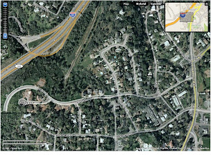
Satellite Photographs of Loughhaven
Here are the satellite photographs (click on a picture to see the full size image) of Loughhaven retrieved from the web. North is at the top of the picture. This picture was taken before construction was begun on our house. This picture was taken after the place was built. Interestingly, the house did not appear on Yahoo maps until we actually moved in, the week before the satellite showed a tree covered lot.
 Same shot with the streets labeled.
 Finally, a map of the same area. Note that the Interstate 80 freeway exits are show.

Microsoft Virtual World has satellite photos from before the land was cleared.


1 comment:
The web page http://www.elbowmagic.com/directions.html may be easier to print and follow.
Post a Comment